Ground Control Points (GCPs) are an important part of drone surveying, photogrammetry, and mapping workflows. They improve aerial data accuracy by linking drone images to real-world coordinates. When placed and measured correctly, GCPs allow surveyors to create reliable maps, 3D models, and detailed site information.
However, mistakes during planning, placement, or measurement can reduce survey accuracy. Even small ground control errors can affect the final deliverables, especially on large construction sites, land surveys, and engineering projects.
Understanding common mistakes and following proper field practices can help you achieve better accuracy and more reliable mapping results.
What Are Ground Control Points?
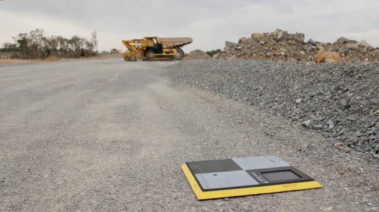
Ground Control Points are clearly marked locations on the ground with accurately measured coordinates. During drone mapping, these points act as reference locations that help photogrammetry software align aerial images with real-world positions.
Survey professionals use ground control points for applications such as:
High-quality Ground Control Points are designed to provide clear visibility, durability, and reliable positioning during aerial data collection.
Common Ground Control Point Mistakes
1. Using Too Few Ground Control Points
One of the most common mistakes is using an insufficient number of GCPs for a project.
Some operators assume that a few points are enough, but large survey areas require proper distribution to achieve consistent accuracy. Without enough reference points, errors can increase, especially around the edges of the survey area.
How to Avoid This Mistake
Before starting a drone survey:
-
Evaluate the size of the mapping area
-
Consider the required accuracy level
-
Plan GCP placement before the flight
-
Add more points for complex terrain or larger sites
A well-planned control network helps improve horizontal and vertical accuracy.
2. Poor Placement of Ground Control Points
The location of each control point directly affects mapping accuracy. Incorrect placement can make it difficult for software to identify points correctly.
Common placement mistakes include:
-
Putting multiple points too close together
-
Leaving large areas without control points
-
Placing targets near obstacles
-
Choosing locations with poor visibility
Best Practices for GCP Placement
Place ground control targets:
-
Evenly throughout the survey area
-
Near corners and boundaries
-
Across different elevation areas
-
In open spaces visible from the drone
A balanced layout allows mapping software to correct errors more effectively.
3. Using Low-Visibility Targets
Ground control points must be easy to identify in aerial images. Small, unclear, or poorly designed targets can create confusion during data processing.
For example, a target that blends into the surrounding environment may be difficult to locate after the drone flight.
How to Improve Target Visibility
Use targets that:
-
Have strong color contrast
-
Are large enough for the flight altitude
-
Remain stable in outdoor conditions
-
Are clearly visible from above
Professional survey markers help reduce identification errors and speed up processing.
4. Incorrect Coordinate Collection
Accurate coordinates are the foundation of successful drone mapping. If the location data is incorrect, the final map may contain positioning errors.
Common causes of inaccurate measurements include:
-
Incorrect GPS setup
-
Wrong coordinate system
-
Poor satellite connection
-
Manual recording mistakes
-
Incorrect elevation information
Ways to Improve Coordinate Accuracy
Before collecting measurements:
-
Verify GPS equipment settings
-
Confirm the coordinate reference system
-
Check recorded data
-
Re-measure important points when needed
Using RTK GPS or surveying-grade equipment can significantly improve coordinate reliability.
5. Ignoring Coordinate Reference Systems
A coordinate reference system defines how geographic positions are represented. Using an incorrect system can cause alignment problems during processing.
For example, drone images and GCP coordinates must use compatible settings for accurate results.
Important Information to Confirm
Always check:
-
Coordinate system
-
Projection type
-
Measurement units
-
Vertical datum
Correct settings ensure that the collected data matches the final mapping requirements.
6. Forgetting About Check Points
Many people confuse ground control points with check points. While both support accuracy assessment, they serve different purposes.
Ground control points help improve the model, while check points independently evaluate accuracy.
Why Check Points Matter
They help you:
-
Measure final map accuracy
-
Identify processing errors
-
Validate survey quality
-
Confirm project requirements
Using separate check points provides a more realistic evaluation of your mapping results.
7. Failing to Consider Environmental Conditions
Environmental conditions can affect ground control data quality. A target that is visible during setup may become difficult to identify later.
Potential issues include:
-
Changing shadows
-
Moving vegetation
-
Weather conditions
-
Construction activity
How to Prevent Environmental Issues
Choose stable locations and regularly inspect targets during the project. Secure markers properly to prevent movement caused by wind, traffic, or other disturbances.
How to Create a Better Ground Control Workflow
A successful drone survey requires preparation before collecting aerial data.
Before the Flight
Follow these steps:
-
Review the project requirements
-
Select appropriate target locations
-
Prepare durable markers
-
Confirm equipment settings
-
Plan flight coverage
During Data Collection
Make sure to:
-
Capture clear images of all targets
-
Record accurate coordinates
-
Verify target locations
-
Monitor environmental changes
After the Survey
Before processing:
Final Thoughts
Ground Control Points play a major role in producing accurate drone survey results. Mistakes such as poor placement, incorrect measurements, and insufficient control points can affect mapping quality.
By planning carefully, using visible targets, collecting accurate coordinates, and following proper surveying practices, professionals can reduce errors and improve project accuracy.
Whether you are working on construction mapping, aerial inspections, or land surveying, reliable ground control is essential to creating precise, dependable geospatial data.


 Search in Classifieds
 Search in Groups
 Search in Polls
 Search in Members
 Search in Members
 Search in News
 Search in Businesses
 Search in Contests
 Search in Events
 Search in Music Albums
 Search in Music Songs
 Search in Quotes
 Search in Site Team



Share this page with your family and friends.